MESOSCALE DISCUSSION 0574 NWS Storm Prediction Center Norman OK 0105 PM CDT Tue Apr 30 2024 
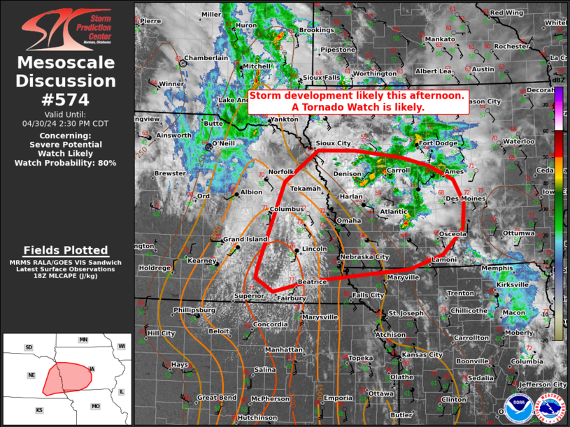
AREAS AFFECTED...portions of eastern Nebraska far northeastern Kansas...western Iowa and northwest Missouri CONCERNING...Severe potential...Watch likely VALID 301805Z - 301930Z PROBABILITY OF WATCH ISSUANCE...80 percent SUMMARY...Isolated storm development is possible by 19-20z across parts of eastern NE and far northeast KS. Initially supercells may support a risk for all hazards. DISCUSSION...As of 1800 UTC, visible imagery showed deepening cumulus towers east of a weak surface cyclone across portions of eastern NE and northern KS. Signs of subtle forcing for ascent ....... more |
MESOSCALE DISCUSSION 0573 NWS Storm Prediction Center Norman OK 1212 PM CDT Tue Apr 30 2024 AREAS AFFECTED...parts of south central New York...northeastern Pennsylvania CONCERNING...Severe potential...Watch unlikely VALID 301712Z - 301945Z PROBABILITY OF WATCH ISSUANCE...20 percent SUMMARY...Intensifying thunderstorms, possibly including a gradually organizing cluster, may pose increasing potential for marginally SEVERE HAIL and wind by 2-4 PM EDT. It is still not clear that a severe weather watch will be needed, but trends will continue to be monitored. DISCUSSION...Downstream of remnant mid-level troughing crossing the lower Great Lakes region, modest ....... more |