Southern Indiana Weather Spotter's Reference
Current Mesoscale Discussions for the USA

Checks for Severe Potential, Heavy Rain, Heavy Snow, and Freezing Rain
Note: This page will reload every 2 minutes. Mesoscale Discussions are listed in the order issued.
Click on the MORE link below to view further details of the SPC Mesoscale Discussions.

MESOSCALE DISCUSSION 0737
NWS Storm Prediction Center Norman OK
0700 PM CDT Thu May 09 2024

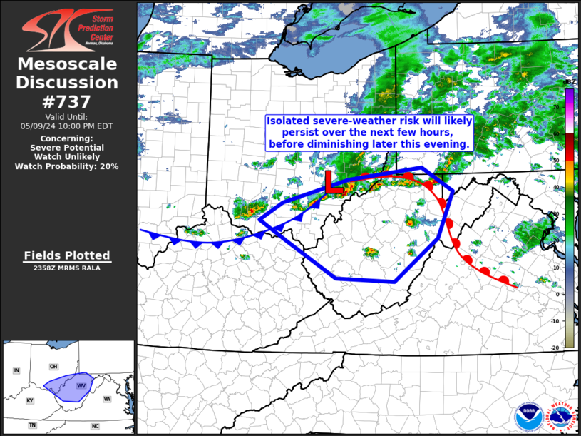
AREAS AFFECTED...southeastern Ohio and West Virginia

CONCERNING...Severe potential...Watch unlikely

VALID 100000Z - 100200Z

PROBABILITY OF WATCH ISSUANCE...20 percent

SUMMARY
...Local/isolated risk for STRONG WIND GUSTS will persist for
a few hours. WW not anticipated.

DISCUSSION...Latest radar shows an uptick in convection from
southern Ohio to northern West Virginia, in the vicinity of a
southeastern Ohio surface low, and attendant baroclinic zones.
Ahead of the front, RAP-based objective analysis suggests that
diurnal heating has pushed mixed-layer CAPE to near
....... more

MESOSCALE DISCUSSION 0736
NWS Storm Prediction Center Norman OK
0624 PM CDT Thu May 09 2024

AREAS AFFECTED...northeastern Louisiana...southeastern
Arkansas...and west-central Mississippi

CONCERNING...Severe potential...Watch possible

VALID 092324Z - 100100Z

PROBABILITY OF WATCH ISSUANCE...40 percent

SUMMARY
...Storms continue to gradually increase across the
west-central Mississippi Vicinity. Additional storm development may
require WW issuance to be considered.

DISCUSSION...Latest radar loop shows convection gradually increasing
in coverage and intensity across the west-central Mississippi
vicinity, in the vicinity of a west-to-east baroclinic zone.
....... more