Southern Indiana Weather Spotter's Reference
Current Mesoscale Discussions for the USA

Checks for Severe Potential, Heavy Rain, Heavy Snow, and Freezing Rain
Note: This page will reload every 2 minutes. Mesoscale Discussions are listed in the order issued.
Click on the MORE link below to view further details of the SPC Mesoscale Discussions.

MESOSCALE DISCUSSION 0514
NWS Storm Prediction Center Norman OK
0347 PM CDT Thu Apr 25 2024

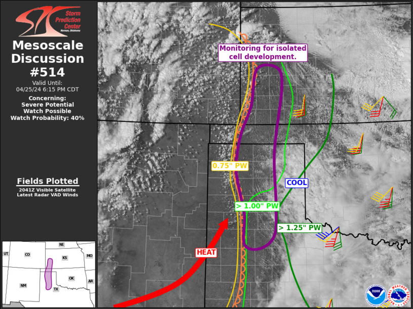
AREAS AFFECTED...southwest Kansas into the central Texas Panhandle

CONCERNING...Severe potential...Watch possible

VALID 252047Z - 252315Z

PROBABILITY OF WATCH ISSUANCE...40 percent

SUMMARY
...A narrow zone of isolated storm potential exists from
southwest Kansas into the central Texas Panhandle, with conditional
supercell threat.

DISCUSSION...Clouds hampered heating for much of the day from the
South Plains into most of the TX Panhandle, but boundary layer
mixing continues with decreasing clouds. High-based cumulus have
formed within the warmer, deeply mixed air mass
....... more

MESOSCALE DISCUSSION 0513
NWS Storm Prediction Center Norman OK
0223 PM CDT Thu Apr 25 2024

AREAS AFFECTED...northeast Colorado into much of northwest Kansas

CONCERNING...Severe potential...Watch likely

VALID 251923Z - 252200Z

PROBABILITY OF WATCH ISSUANCE...95 percent

SUMMARY
...Storms are expected to rapidly develop along the boundary
from northeast Colorado into northwest Kansas, and far southwest
Nebraska. Very large hail is likely, along with A FEW TORNADOES and
DAMAGING GUSTS.

DISCUSSION...Strong heating persists across the region, now on both
sides of a stationary front extending from northeast CO into
northwest KS. Southeasterly surface winds have
....... more