The Southern Indiana Weather Spotter's Reference
Serving the Tri-State with
LIVE
Radar & Weather Updates
Forecast:
FORECAST FOR THE EVANSVILLE, INDIANA AREA......
NATIONAL HEADLINE:
More severe storms, tornadoes poised to pounce on central US this week
Links:
Advanced Forecast
Amateur Radio
Amateur Satellites
Climatology
Current Conditions
Disaster Maps
Earthquake
Flood
Forums
Forecast
Home
Hurricanes
Jumpstart
Links
Models
NWS Offices
Radar
Satellite
Spotter Training
Storm Chase Live
Watches/Warnings
Winter
Local Forecast:
Indianapolis NWS
Louisville NWS
Paducah NWS
Nationwide
Current Visitors:
50
......
Weather Channel Updates
......
Accuweather Headlines
.......
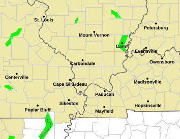
Alerts
Heads Up:
- National
- SW Indiana
Warnings:
- Local
- Regional
- National
- Live Updates
Indiana Map:
- Warnings
- Alerts Console
- Tornado Alarm
Regional Map:
- Warnings
Severe Reports:
- National
- Tri-State
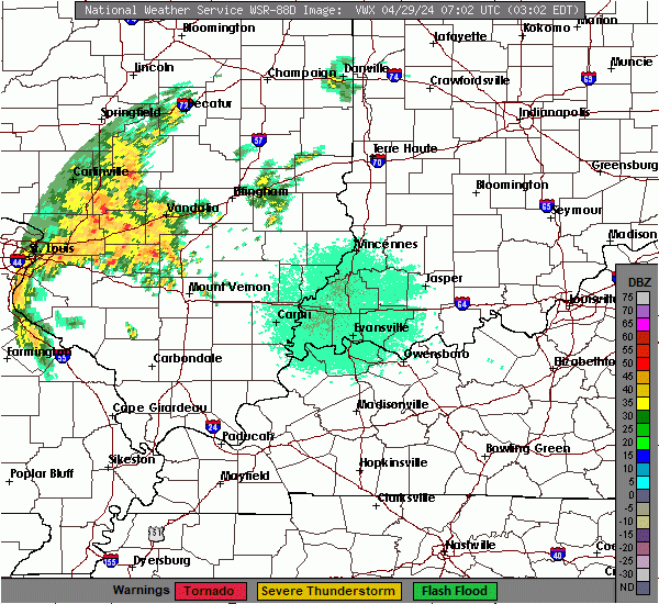
Radar
Local:
- Evansville
- Louisville
- Paducah
- Regional
- National
Services:
- Radar Sentry
Lightning
Strikes:
- Local
- Regional
- National
- GOES (GML 1)
- GOES (GLM 2)
Alternate:
- National
Past Strikes:
- Years
Hazards
Outlook:
- Indianapolis
- Louisville
- Paducah
Counties:
- Crawford
- Dubois
- Vanderburgh
Cetegorical:
- Tornado
- Hail
- Wind
- 2Hr Lightning
Indices
- SPC HRRR
- SPC HREF
- Env Browser
- Tornado
- Supercells
- Hail
- Lifted Index
- Lapse Rates
- SBCAPE/Wind
- Hail Size
- Hail Prob
- Wind Shear
- SRH (0-3km)
- Upper Winds
- Dewpoints
- PWAT
Stats
Tornadoes:
- Year-to-Date
- Daily Count
- Deadly
- Summaries
- Charts
- Database
- Fatalities
Precipitation:
- Rainfall
- Snow Depth
Wx Stations:
- Dubois
- Archive
- Wind Chill
Warnings:
- Today
- Last 3 Hrs
- Last 24 Hrs
Reports
Nat'l (SPC):
- Today
- Yesterday
- Interactive
Nat'l (Wx Spotter)
- Today
- Yesterday
Tri-state:
- Today
- Yesterday
LSR:
- Louisville
- Paducah
- Indianapolis
All:
- LSR
Zoom
Information provided by this site is experimental. Consult the National Weather Service for official weather information
Stats
Load (Plot)
Http (Plot)
DNS (Plot)
RTT (Plot)
Load (Timing)
Radar
Alerts
Fcast
Stress
Proc
Load
DNS
Diag
News
Plot
Internet
CPU
Risk
Post
html loading
page loading
Watches In Effect
Watches Pending
Local Alerts
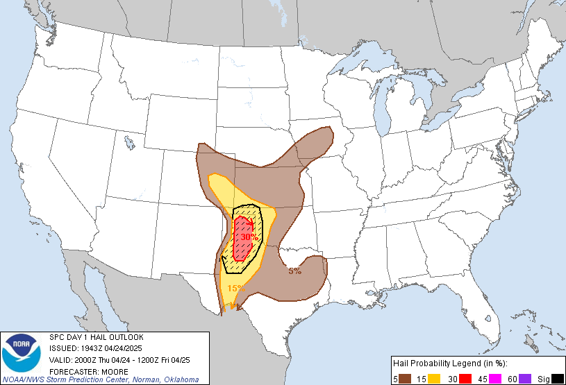
Severe Outlook
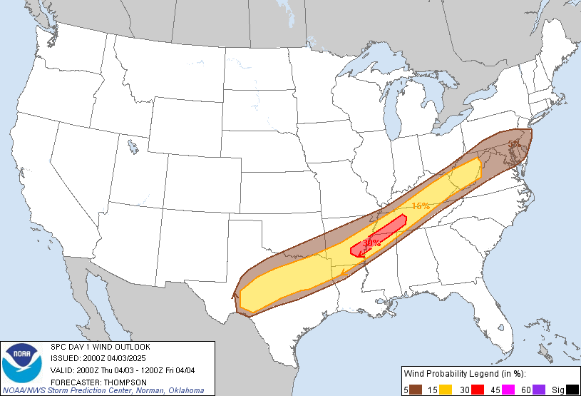
NATIONAL OUTLOOK
Marginally severe wind gusts and hail will be possible today across south Texas, the lower Mississippi Valley
...more...
.........................NEWSALERT/WATCH USING NEW CAP V1.2 SCRIPT...................


 FORECAST FOR THE EVANSVILLE, INDIANA AREA......


 ......


