The Southern Indiana Weather Spotter's Reference
Serving the Tri-State with LIVE Radar & Weather Updates  
  Forecast: 

    FORECAST FOR THE EVANSVILLE, INDIANA AREA......  
Links:   
Advanced Forecast   
Amateur Radio   
Amateur Satellites   
Climatology   
Current Conditions   
Disaster Maps   
Earthquake   
Flood   
Forums   
Forecast   
Home   
Hurricanes   
Jumpstart   
Links   
Models   
NWS Offices   
Radar   
Satellite   
Spotter Training   
Storm Chase Live   
Watches/Warnings   
Winter   
Local Forecast:   
Indianapolis NWS   
Louisville NWS   
Paducah NWS   
Nationwide   
  Current Visitors:  29
follow on facebook  
follow on facebook  

Moderate Risk of Severe Weather (0100Z - 1200Z)
o
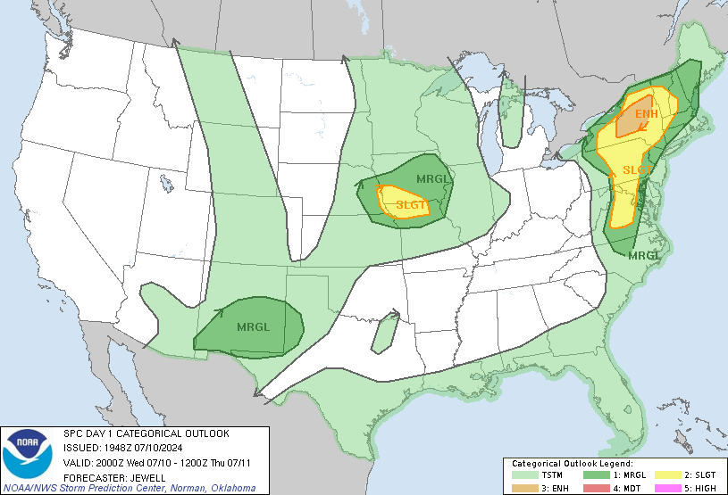
Severe thunderstorms are expected this evening into tonight across much of the southern Plains and lower Missouri Valley. The greatest severe threat will be from north Texas northeastward through Oklahoma into far southeast Kansas and southwest Missouri. All hazards will be possible including tornadoes, with some strong, damaging wind gusts above 70 mph, and very large hail exceeding 2 inches in diameter. Scattered severe storms will also be possible later this evening in parts of west-central and southwest Texas. Isolated severe storms are also expected to occur this evening in parts of the mid to upper Mississippi Valley northeastward into the Great Lakes.....more.....