|
| The Southern Indiana Weather Spotter's Reference |
|
Serving the Tri-State with LIVE Radar & Weather Alerts |
|
|
| |
Forecast: |
|
|
 FORECAST FOR THE EVANSVILLE, INDIANA AREA...... FORECAST FOR THE EVANSVILLE, INDIANA AREA......
|
|
|
|
|
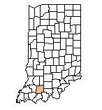
| Dubois County Hazardous WeatherCast
|
|
This
Afternoon

High: 85 °F Mostly Sunny
| Tonight

Low: 59 °F Slight Chance
Sprinkles
| Thursday

High: 87 °F Patchy Fog
then Sunny
| Thursday
Night

Low: 57 °F Clear
| Friday

High: 88 °F Sunny
| Friday
Night

Low: 59 °F Mostly Clear
| Saturday

High: 91 °F Sunny
| Saturday
Night
Low: 62 °F Mostly Clear
| Sunday
High: 92 °F Mostly Sunny
|
|
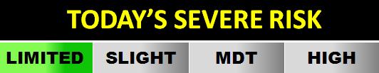
| Severe Risk Levels: |
Low, Thunderstorms, Marginal, Slight, Enhanced, Moderate, or High Risk of Severe Thunderstorms |
| |
Always check the dates within this report to insure the information is current. |
| |
This outlook is experimental. Consult the National Weather Service for forecast information |
|
|