
|
| The Southern Indiana Weather Spotter's Reference |
|
Serving the Tri-State with LIVE Radar & Weather Updates |

|
|
| |
Forecast: |
|
|
 FORECAST FOR THE EVANSVILLE, INDIANA AREA...... FORECAST FOR THE EVANSVILLE, INDIANA AREA......
|
|
|
|
|
| Today's Quantitive Precipitation Forecast |

|
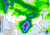
| Quantitive Precipitation Forecasts (Days 2-5) |
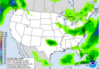
Day 2
|
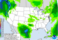
Day 3
|
Day 4-5
|
5 Day Total
|
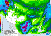
| Excessive Rainfall Forecasts (Days 1-5) |

Day 1
|

Day 2
|

Day 3
|

Day 4
|

Day 5
|
|
|


 PQPF
PQPF